Cities Knowledge Graph Project Completion Webinar
Cities Knowledge Graph
Planning a Smart Nation builds on knowledge
This research aims to harness rapidly growing and diversifying data streams to improve the planning and design of cities. It will do so by developing an innovative digital platform, known as the Cities Knowledge Graph (CKG), designed to combine data and share knowledge about cities, and to inject new precision and responsiveness to static instruments of planning, such as the city master-plan.
Cities Knowledge Graph from aurelvr on Vimeo.
This general objective has three specific aims:
1. Understanding city dynamics.
Cities are rapidly changing as they strive to accommodate the further 2.5 billion people that will be living in urban areas by 2050. Managing this dynamic means harmonising internal conflicting demands – be it for housing, business, leisure, mobility, energy, or ecology – as well as managing external shocks.
2. Improving city data and knowledge systems.
Data on every aspect of everyday city life is rapidly growing in volume (generating ‘big data’), diversity of sources (from mobile phone to satellite) and variety of types (demographic, spatial, temporal). New ways of managing that data are needed to improve city planning knowledge.
3. Integrating city planning.
Current models of city planning worldwide, are organised around distinct sub-disciplines or knowledge domains – land-use, building control, transport, and ecology – each with its own data collection cultures. Ensuring sustainability and resilience in future cities requires deeply integrated planning and design processes.
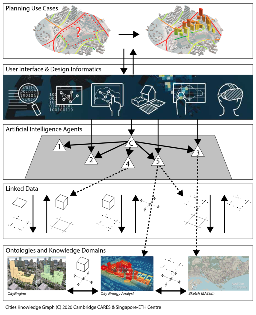
The project will develop a pilot for a comprehensive Cities Knowledge Graph (CKG). The CKG is a digital knowledge management platform that emphasises the legibility, or inter-operability, of different kinds of city-relevant data (building form, transport flows, underground infrastructure, humidity, or temperature).
We will investigate how such diverse kinds of data can be made mutually legible by developing a semantic, extendible representation of relationships between them, what is known as a knowledge graph. This process, if demonstrated, will help planners and designers generate more reliable information and knowledge about cities – sites, neighbourhoods, areas or systems – and how they change.
More specifically, the CKG will help planners and designers by:
• Automating some aspects of data gathering and processing, and generating useful information and knowledge about cities.
• Integrating concepts and targets from different city planning departments, based on distinct knowledge domains, to make more rounded planning questions.
• Supporting advanced scenario planning features, allowing planners to study and compare ‘parallel worlds’ with different variants of their planning proposals.
We will demonstrate, test, and improve the CKG through a number of use cases, through regular feedback from planners, industry and government, domain experts, and other stakeholders.
Cities Knowledge Graph is an Intra-CREATE collaborative project under the urban systems theme. The project brings together expertise from Cambridge CARES (the Cambridge Centre for Advanced Research and Education in Singapore, established by the University of Cambridge) as the host institution of the project, and SEC (the Singapore-ETH Centre, established by ETH Zürich). The team is led by principal investigators from the University of Cambridge and ETH Zürich.

The Cities Knowledge Graph platform bridges the gap between planning use cases and planning knowledge domains. This project will leverage existing expertise and tools from SEC and CARES; the diagram integrates existing work and expertise by CIVAL (user interface and design informatics), Engaging Mobility (showcasing their Sketch MATsim software), the team developing the City Energy Analyst toolbox, and former ETH spin-off ESRI CityEngine.
This research is supported by the National Research Foundation, Prime Minister’s Office, Singapore under its Campus for Research Excellence and Technological Enterprise (CREATE) programme.

Partners
Cambridge Centre for Advanced Research and Education in Singapore (CARES)
Investigators
Management and Coordination
Researchers
Collaborator
Kees Christiaanse Architects and Planners (KCAP)
Advisors
Urban Redevelopment Authority (URA)
Stadt Zürich Geomatics + Surveying
